Monthly Archives: March 2015

Twelve Mile Beach – Fat Bike Ride

15+ miles – Sand Beach – Pictured Rocks National Lakeshore, Michigan.

Highlights:  12 miles of undeveloped Lake Superior shoreline.

The Hurricane River

The Hurricane River

Trailhead:  This ride starts at the Hurricane River Campground in Pictured Rocks National Lakeshore.  The campground is about 12 miles west of Grand Marais on H-58.  Here you will find 21 rustic campsites split between 2 loops.  The lower loop is right by Lake Superior while the upper loop is closer to the road.  All campsites are first-come, first-served in the National Lakeshore.  Parking for this ride is at the picnic area by the Hurricane River at the entrance to the lower loop.  There is also an overflow lot closer to H-58 that you will pass on your way in.  In the campground there are pit toilets and potable water if you need to fill your bottles before your ride.

Driving Directions >>

The Ride: From the parking area follow the path out to the shoreline.  At the bottom of the short set of stairs go to left and immediately cross the mouth of the Hurricane River.  Every time I have been here in the summer I have been able to find a spot to cross that is not more than a few inches deep.  In early spring the water is probably a little higher.  After the river, the smooth sand of 12 mile beach begins.  Expect to find a mix of soft sand and small cobblestones along most of this route.

After about 0.7 miles you get to a section where the H-58 road runs right along the shore for just over a mile.  You will be able to see and hear the road traffic and you are also likely to encounter more beach walkers and rock hunters in this area.  In the middle of this section Sullivan Creek flows out to Lake Superior.  Just before the stream crossing you will see stairs coming down from a new beach access that was opened in 2012.  At the top of the steps there is parking for about 20 cars and a rustic restroom.  This would also be a good access point for this ride.

12-mile-beach-fat-bike

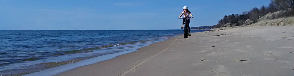
Smooth sand riding on Twelvemile Beach.

After the road bends back away from the Lake you will likely have the next mile of beach all to yourself until you reach the Twelvemile Beach Campground at about 3 miles into the ride.  This is one of my favorite rustic campgrounds in Michigan.  There are 36 campsites on top of a sandy bluff overlooking Lake Superior.  I encountered a few more people on the beach near the campground.  After this I had the beach all to myself for the rest of the ride.  The Lakeshore Hiking Trail also runs parallel to the shore for all of Twelvemile Beach, but I did not see any hikers during my ride.

At about 2.5 miles past the campground or 5.6 miles into the ride you will cross Sevenmile Creek.  When I rode through it was only about 4 inches deep.  Just before the creek a bald eagle flushed from top of a tree and flew up the shore in front of me.  About a half mile later I saw him again and he did the same thing.  On the third time he started up shore again, but then turned and headed way out over the lake and circled around behind me.  I was lucky to get 3 close up encounters on the same ride.

12-mile-beach-ride

It is hard to see, but the dark spot over the end of the trees is the bald eagle on Twelvemile Beach.

The next 2.4 miles of beach after the creek is more smooth riding on a mix of sand and cobblestones.  At 7.5 miles into the ride you come to a small point where there are some bigger sandstone rocks on shore.  I tried to stop and take a break here, but I was immediately attacked by a swarm of  biting black flies.  It was a really cool spring and I think this pushed bug season in the Upper Peninsula into July on this year.  From what I have heard the bugs are usually the worst from the middle of May through late June.  I tried to out run the flies and when that didn’t work I decided that it was time to turn around.

rock-point-12-mile-beach

The rocks at the turn around point for this fat bike beach ride.

I originally hoped to continue on another 4.5 miles and ride the entire entire length of Twelvemile Beach up to where the Pictured Rocks Cliffs begin.  The biting flies changed this plan and also made the ride back a little less enjoyable.  When I was heading out I didn’t really even notice it, but I was riding into a very light lake breeze.  It must have been just enough to keep the flies from bothering me.  After I turned around I think they were able to ride the breeze and keep up with me.  For some reason they really liked my right shoulder next the strap of my Camelback.  I must have taken at least 20 hits in the exact same spot.

Even with the flies this still ranks as one of my favorite beach rides on my fat bike.  I can’t wait to get back up here and try to do all of Twelvemile Beach.

fat-bike-by-stream

Crossing Sevenmile Creek on the Twelvemile Beach fat bike ride.

Map:

Ride Photos:

A GoPro time-lapse video of the ride.

Post Ride Beverage: Lake Superior Brewing Company is one of our favorite “up north” restaurants and we always make at least one stop here when we are in the area.  The food is good, the beer is good and the atmosphere is perfect for relaxing after a day exploring Pictured Rocks.  If it is a busy weekend they may be out of some of the beer and a couple things on the menu, but I think this is just part of the charm of a small town brewery.

au-sable-lighthouse

The Au Sable Lighthouse

In the Area: The Au Sable Light Station is a 1.5 mile hike (or beach ride) east of the Hurricane River Campground.  You can either hike on the Lakeshore Trail or the beach to get here.  Bikes are not allowed on the trails so please take the beach if you choose to ride out.  I would recommend walking the beach because along the way you will pass the remains of 2 different shipwrecks on shore.

Links:

Make sure to come back and Rate This Ride at the top of this page.


Facebooktwittergoogle_plusredditpinterestlinkedinmailby feather

Riley Trails – Winter Fat Biking

2.7 + miles – Winter Multi-Use Trail – Holland, Michigan

Highlights: Winter riding near the Lakeshore.

riley-trails-sign-2Trailhead: Riley Trails is located on the north side of Holland on Riley St about 4.5 miles west of US 31.  The entrance is on the south side of the road and is marked  with stone pillars holding a wooden sign with red letters.  At the trailhead there is a pit toilet and a few informational boards with maps.

Driving Directions >>

Riley Trails are on 300 acres of county land that was used as a land fill up until 1979.  There are now 7 miles of marked mulit-use trails at this park.  This is not a destination ride, but it is becoming a popular place for locals to put a few miles on their fat bikes in the winter.  Most of the time you will not even know that you are riding around an old dump.  The trails were originally used for mainly cross-country skiing in the late 1980s.  In 2006 management of the property was turned over to Ottawa County Parks and several improvements were made over the next couple years.  The trail system was also remarked and mapped.

After this was done the number of both summer and winter trail users really increased.  The trails are not groomed, but with all of the skier and snowshoe traffic they are usually packed well enough for fat bikes most of the winter.  Although, after significant snow you may want to give it a few days for things to get packed down again.  Also, if there is a big thaw and then a freeze the trails can get too rough to ride.  The warm weather always seems to bring out the walkers and runners and when their footprints freeze things get a little bumpy until they get filled with snow again.

All of the trails are open to exploring on fat bikes, but below I will describe a loop that is most likely to rideable in the winter. If you get out here and the riding conditions are not favorable there are  couple other options nearby.  See the “In the Area” section below for other rides.

The Ride:  in 2012 a 4.5 mile mountain bike loop was pieced together with many of the existing trails.  In the winter the beginning and end of this loop can usually be ridden.  The back half usually doesn’t get enough traffic to pack the snow.  I will explain how to connect the beginning and end of the bike trail with the service road for a winter loop of about 2.7 miles.

riley-trails-fat-bike

This start of the mountain bike trail.

This fat bike ride starts in the southeast corner of the parking lot by a green sign that shows the map for the “Riley Trails Mt. Bike Course.”  Ride past the sign and follow the brown fiberglass posts with mountain bike trial markers.  This first section of trail is fairly straight and flat with just one small hill to climb over.  It makes a right angle as it follows the north and then east borders of the property.  You will see a few side trails heading off to the right, but you will want to stay straight following the bike markers.  At about 0.7 miles you climb a small hill up to a service road.

riley-trails-service-road

The service road at Riley Trails

At this point the trails split off in several different directions and many of these are usually not packed well enough to ride.  However, the service road is usually plowed.  You will want to take a right on the road heading towards the hill from the old landfill.  After about 0.1 miles you will see the mountain bike trail markers heading across the open area to the left.  If the trail looks like it has had some traffic you can try to continue on the marked bike loop.  Most of the time this will not be good to ride and you will want to continue on the service road and go around the gate as it curves to the left.  You will be on this road for the next 0.75 miles as goes around the old landfill.  After a straight section the road curves to the right and then back to the left and you will see a chain link fence that is the southern edge of the property.  The road will go back to the right away from the fence, but you will want to go to the left of the snow pile and pick up the trail along the fence.  The trail will climb up a hill through some pine trees and then after you go back down you will be right next to the fence again.   Continue straight as the mountain bike trail joins back in from the right.  From here you will be able to follow the brown mountain bike markers for the rest of the ride.   After paralleling the fence for about 0.2 miles a marker points you to the right into the pines.

fat-bike-turn-off-riley-trails

Nearing the left turn off on the service road.

You will be in this section of fairly thick pines for about the next 0.6 miles.  This part has some small hills that keep the ride a little more interesting and is also really nice when there is new snow hanging in the trees.  At about 2.2 miles into the ride you turn to the left and leave the pines and enter the hardwoods.  In another 0.1 miles you climb a little rise and then you will want to stay to the right when the trail tees at the top.  Next you drop down the biggest hill of ride and soon you will see the trees opening up to the pond on your left.  This section is more open and tends to drift and be a little rougher than the rest of the trail.  At times you may have to push your fat bike for the last couple hundred feet here.  The bridge over the pond on the left takes you back to the parking area and the end of the loop at 2.7 miles.

Next you can go for another loop or check out the trail map and try to explore some of the other trails.  Staying on the trails closer to the the parking is usually best.

riley-trails-pines-fat-bike

Entering the pines section at Riley Trails.

riley-trails-fat-bike-marke

The mountain bike trail markers.

Ride Map:

Ride Photos: 

GoPro timelapse photos of the winter fat biking loop at Riley Trails.

Post Ride Beverage: Try Big Lake Brewing just 2.5 miles away at 977 Butternut Drive #4.  This place is all about the beer.  If you are hungry you can get takeout from one of the nearby restaurants.

5504304713_51b78b1b9a_z

Big Red at Holland State Park

In the Area: About 1.25 miles west of Riley Trails you will find a Lake Michigan beach access off the end of Riley Street.  The township usually does good job of keeping the bike paths plowed, making this is an easy ride on the fat bike out to the lake.  If the beach is not snowed in you can ride south for about 3.5 miles to Holland State Park.  If the beach conditions are not good for riding the bike path along Lakeshore Drive is a good alternate route.  Combining the beach and bike path would also be a good option for a loop.

Links:

 Make sure to come back and Rate This Ride at the top of this page.


Facebooktwittergoogle_plusredditpinterestlinkedinmailby feather

Merrell Trail – Winter Fat Biking

6.4 miles – Winter Single Track – Rockford, Michigan

Highlights: Groomed snow at the top trail in West Michigan.

Trailhead: The start of the Merrell Trail is somewhat hidden off 10 mile road just east of US 131 in Rockford, MI.  After exiting the highway head east  and make a quick right hand turn at the first stop light.  The pavement ends in about 300 feet and it turns to a narrow gravel road that leads to the trailhead.  The parking is just past the big water tower, you can look for this if you are not sure where to go.  In the summer there is portable toilet, but in the winter all you will find is a plowed parking lot and information board.

Driving Directions >>

merrell-trailhead-winter

The start of the Merrell Trail is just up the hill from the parking area.

The Merrell Trail opened in 2012 and quickly became a favorite of local mountain bikers.  The trail gets it’s name from the Merrell outdoor shoes.  Merrell is a brand of the footwear  giant Wolverine World Wide which is also headquartered in Rockford, MI.   Wolverine provided much of the funding to have this trail professionally built and their employees also worked with the West Michigan Mountain Biking Alliance to help with the build.  The result is fast and flowing single track that is fun to ride in both summer and winter.

The trail is currently being groomed for fat biking in the winter by volunteers with snowmobiles pulling drags.  Make sure to check trail conditions on their Facebook page before heading out.  The trail will occasionally be closed when there is a big thaw.

The Ride: The trail starts by the sign board on top of the small hill to the west of the parking area.  Note that the direction the trail is ridden changes based on the day of the week.  On Tues, Thurs and Sat start to the left and follow the yellow markers.  Sun, Mon, Wed and Fri start to the right and follow the red markers.  I should also mention that this trail was designed for bikers, but it is considered a multi-use pathway.  All other users are asked to go in the opposite direction.  I will be describing the yellow direction below.

The first 0.4 miles of trail heads almost straight south and serves as an access to the main loops.  After this stay to the left and continue on to the 0.75 mile Chameleon Trail.  You will soon start seeing the rolling terrain that this trail is known for.  At the end of Chameleon there is a cut back that you could take over to Mix Master for a shorter loop of about 2.75 miles.

To stay on the main trail continue slightly left to pick up the Wilderness Trail.  This trail twists around in some fairly thick pines for a little while and then opens up back in the hardwoods.  This section is probably some of the finest trail you will find in West Michigan.  It is fast and flowing with  big berms in the corners.  It is a little slower on the fat tires in the snow, but still fun to ride.  At about 2 miles into the ride you get down near the bottom of the valley and the end of the Wilderness Loop.

merrel-winter-sawtooth-br

The snow covered bridge that leads to the Sawtooth Trail in the summer.

The Wynalda Loop heads off to left here and if it looks like it has been packed, head up that way.  The other option is to continue straight to post 8 and pick up Siren.  The Wynalda Loop at 1.75 miles is the longest named trail at Merrell.  This loop has a decent amount of climbing and is definitely harder in the snow.  2 different sections of this trail run along the edge of the treeline by the sports fields.  Winds from the north or west can drift these open parts over and you may have to do some hike-a-fat-bike at times.  This loop then dumps you out almost right back where you turned off.  Stay to the left again and follow Siren along bottom of the valley.

Continue on Siren until you get to post 6 which is  the turn off for Phaser. Along the way you will pass the snow covered bridges at the start the Sawtooth Trail.  Sawtooth is too tight to be groomed and usually not passable in the winter.  The turn off for Phaser is also easy to find because the rest of Siren is not groomed either.  Phaser is 0.75 miles long and takes you back up and out of the valley.  As you top out at the end of the trail you will see a picnic table and an information board with a trail map.  This is good spot to take a well earned rest.

merrell-winter-map-stop

The Moonlander by the trail map at marker #4 on the Merrell Trail..

From here the Mix Master Trail is a fun winter ride as it twists it’s way through the west part of the property.  After another rolling 1.5 miles this trail spits you back out on the straight connector heading back to the parking lot in less than a 0.5 mile .  If you still want to put on some more miles, at the end of Mix Master you can take a hard right and head out for another loop by connecting back up with Chamelon.

All these trails and names may sound a little complicated, but if you look at the map below it will make more sense.  The start of each trail is also marked by a metal sign with the trail names in cut out letters.

Ride Map:

merrell-trail-map

Here is a photo of the map posted at the trailhead.  *Click the map to see a larger version*

The winter route in Strava:

Ride Photos: 

GoPro timelapse photos of the winter fat bike trail at Merrell.

Post Ride Beverage: The Rockford Brewing Company looks worth checking out, but we have not made it there yet.  If you are a Rockford local please give us your recommendation in the comments below.

In the Area:  Make sure to come back and ride Merrell in the dirt.  Rockford is also home to another one of West Michigan’s top mountain bike trails at Luton Park.  This stacked loop trail system has just over 9 miles of rolling single track.  Luton Park can be found 4 miles west of Merrell, right on 10 mile road.  Luton is a multi-use trail and at times some sections will get packed well enough to be ridden in the winter.  See more at Friends of Luton Park on Facebook.

Links:

 Make sure to come back and Rate This Ride at the top of this page.


Facebooktwittergoogle_plusredditpinterestlinkedinmailby feather